


Proposed Route
Routing Process Summary:
Note – this is not intended to be all-inclusive but rather outline the process and steps PSEG took to develop a Proposed Route. More detailed information is included as part of PSEG's Certificate of Public Convenience and Necessity (CPCN) submission to the Maryland Public Service Commission (PSC) and is available for further review and public comment as part of that process.
Where We Started:
In December of 2023, PJM selected a PSEG proposal to resolve forecasted reliability violations on the electric transmission system that serves Maryland and surrounding states as represented by the pink line in the map below:
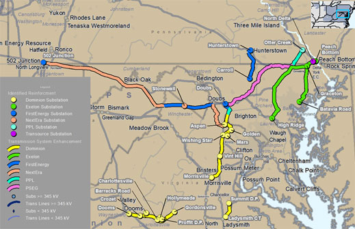
This pink line is representative of one part of a bid proposal PSEG submitted as options to address the reliability needs that PJM has forecasted for the region. The route was developed earlier in 2023 by PSEG using publicly available information and was considered at that time to be preliminary or “bid level”.
| Progress to July Public Release | Public Comment Process |
| Route Analysis & Proposed Route |
Next Steps |
Progress to July 2024 Public Release:
After PJM’s selection, PSEG engaged a routing and siting consultant to conduct a routing analysis to connect the endpoint at the existing BGE right-of-way in northern Baltimore County, Maryland to the endpoint at the existing Doubs Station in Frederick, Maryland. The transmission line routing process was iterative and began with assembling a multidisciplinary siting team. The siting team included members experienced in high voltage transmission line siting, project management, environmental and cultural resources, engineering, permitting, real estate, construction, and agency and public outreach.
The team started the routing analysis by defining a Study Area shown as a black dash below. The goal was to define an area to use for analysis of viable route alternatives between the endpoints. The Study Area was developed to avoid metropolitan areas where routing is restricted by the dense built environment (such as the City of Frederick to the west), and to limit crossings of existing 500kV infrastructure to the extent possible due to engineering and service complexities (which is why the existing 500kV line bounds the Study Area to the south and east).
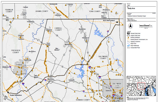
The siting team aligned on routing and siting criteria that would be used to develop potentially viable route alternatives within the Study Area. These included Environmental, Land Use, Social, and Engineering criteria. PSEG determined that potentially viable routes for a 150' wide Right-of-Way should avoid residences, businesses or other built infrastructure to the extent possible as buildings and structures cannot coexist within the Right-of-Way.
Within the Study Area, the PSEG team then assembled information on existing conditions, opportunities and sensitivities into a geographic information system (GIS) database. This included federal, state and local data available publicly or obtainable directly from the respective source (such as development plans from a county). Siting team members obtained field level information to identify additional sensitivities and opportunities that warranted revisions or deletions to the GIS data. Field level data was obtained from public roadways (windshield survey) to help confirm and identify information not available from reviewing aerial images or in the GIS data (for example new construction or other infrastructure).
The resulting 10 Alternative Route corridors (labeled as Routes A – J) were released publicly on July 8, 2024. A screenshot of the interactive mapper from www.mprp.com follows below:
Public Comment Process:
Public information sessions (held July 9th, 10th & 11th in the three counties within the Study Area) along with the online survey tool (open from July 8th to July 26th) were utilized to collect public comments. Additional comments were also obtained from PSEG’s project e-mail and phone hotline as well as correspondence received.
In total, the team reviewed and analyzed over 5,300 comments from the public. Comments were categorized and geo-located into the team’s GIS database where possible (when addresses were provided).
Adjustments were made to the Alternative Routes based on the comments received. While not every requested change or recommendation was feasible to incorporate, the siting team did receive valuable comments that helped the Company identify sensitivities not previously captured. For example, based on numerous requests from the public, the routing team avoided routing through the Peace and Plenty Historic District in Frederick County. As another example, public comments revealed a future development area (England Woods Development) that was a previously unidentified development plan that the routing team, was able to route around.
The routing team also received a high volume of comments requesting that the company consider paralleling the existing 500kV infrastructure that forms the southern and eastern borders of the Study Area. Following the public information sessions, per feedback from the public, the Routing Team performed an additional review of routing adjacent to the Conastone-Brighton-Doubs ROW between the MPRP endpoints. This review re-confirmed that paralleling the existing ROW was infeasible for the majority of the length. Such an alignment could result in more than 90 residences and community buildings within the MPRP ROW. As a result, The Routing Team did not continue with further evaluation of this alternative for this reason.
Route Analysis & Proposed Route
The adjusted 10 Alternative Routes were reviewed using the siting criteria quantified with GIS desktop data as modified by field collected data. The siting team reviewed the results of the routing analysis to discuss quantitative and qualitative factors associated with each route and select the Proposed Route. View summary of the criteria.
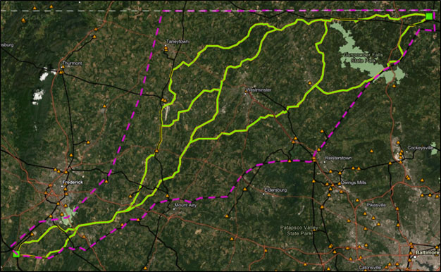
The goal of the routing process is to identify a Preferred Route that meets the electrical, engineering, and planning requirements in a reliable way while minimizing potential impacts to the natural and built environments. In practice, there are tradeoffs among the evaluation criteria, and it is not possible to minimize all sensitivities for a given route. As a result of the extensive data gathering and analysis, comments received from the public, field collected data , and the siting team's knowledge and experience, the siting team chose to carry forward Route H as the Proposed Route for the Project.
Route H was selected as it performed well in the land use, social and engineering criteria categories. For example, Route H impacted fewer conservation easements, had fewer residences and community facilities in close proximity to the Right-of-Way, and it was shorter and had fewer hard turns which reduces cost and complexity. As noted above, there was no one route that has minimal impacts across all four categories.
Click Below to View the Proposed Route Interactive Map

Note: The points of interconnection (project endpoints) are subject to further coordination with PJM and agreements with the interconnected utilities.
Current Field Activity in Rights-of-Way:
Field crews representing PSEG may be in the vicinity of the Proposed Route to conduct initial field studies. These field crews will be working from within the public roads and parks only. These initial field studies do not require access to private property and the field crews will not be engaging property owners to request access.
Initial field studies include:
- Visual construction assessments - To assess existing site conditions.
- Survey activities - To validate public data.
Next Steps:
The Proposed Route is subject to all governmental and regulatory approvals, including a CPCN submission to the Maryland Public Service Commission (PSC).
Next steps include:
- Engineering Due-Diligence and Design Progression
- Public Feedback
- Real Estate Process
- Letters have been sent to landowners on the proposed route introducing the landowners to the land agent assigned to property.
- The letter also explains that PSEG is seeking a temporary right of entry agreement to conduct surveys and other studies needed to assess the suitability of the property for the MPRP and to gather information needed for the CPCN evaluation. A temporary right of entry is not an easement and does not grant permanent property rights or construction rights or obligate the landowner to grant an easement.
- Land agents may visit property owners who have not responded or contacted PSEG to discuss and answer any questions they might have.
- Land agents will be badged as authorized representatives of PSEG/Contract Land Staff.
- Field Surveys
- Permitting and Regulatory Process
PSEG submitted a CPCN application to the Maryland PSC on December 31, 2024.
© 2026 Public Service Enterprise Group Incorporated.
All Rights Reserved.